
Marble は、デスクトップ上にバーチャルな地球儀&世界地図を表示できるソフトウェアらしく、パン&ズームもできるようだ。
Marble is a Virtual Globe and World Atlas that you can use to learn more about Earth: You can pan and zoom around and you can look up places and roads. A mouse click on a place label will provide the respective Wikipedia article.(「Marble Portable | PortableApps.com – Portable software for USB, portable and cloud drives」より引用)
Google 翻訳によると:
マーブルは、地球についての詳細を学ぶために使用できるバーチャル地球儀と世界地図です:あなたは、パンとズームの周りに、あなたが場所や道を調べることができますすることができます。場所のラベルをマウスでクリックするとそれぞれのWikipediaの記事を提供します。
ダウンロード
「Marble Portable | PortableApps.com – Portable software for USB, portable and cloud drives」から「MarblePortable_1.4.0.paf.exe」をダウンロードする。
スポンサードリンク
※Windows7 SP1 64bit で試用した
「PortableApps.com Platform」を使う方法もオススメします。
ファイルの展開
ダウンロードした「MarblePortable_1.4.0.paf.exe」を実行して、ファイルの解凍を開始する。
「日本語」を選択してOK をクリックする。
「次へ」をクリックする。
ファイルの解凍先を指定して、「インストール」をクリックする。
「完了」をクリックする。
使い方
起動のしかた
「MarblePortable.exe」を実行する。
起動したところ。
Google Earth を想像する。
使い方
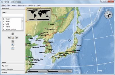
日本を表示したところ。

日本の一部の地域を拡大したところ。
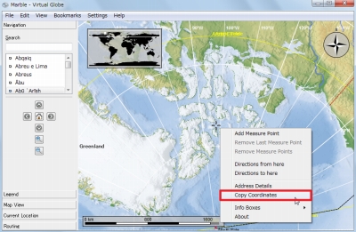
地図を右クリックすると、メニューが表示される。
例えば、クリップボードにコピーという項目を選択すると-
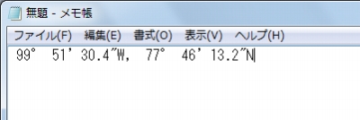
座標がクリップボードにコピーされた。
スポンサードリンク
コメント